Driving Trip -
March 18-20, 2015
Note: click on the thumbnails for a larger image
A few years ago I accompanied my wife to Minneapolis for a few
days. Neither of us had been there before so I figured it
would be
interesting to check out the area. For her, checking out the
area
meant
attending a conference while I got to truly explore the area. This year
the music organization she is involved with once again had their annual
conference in Minneapolis. This
narrative documents the highlights of my travels around the area. It is
not 100% about trains so it may actually appeal to a broader audience
(though not likely).
Thursday March 18, 2015
Thursday was the day with the least amount of time to myself. The
weather was overcast but not too chilly which made for tolerable
walking weather. Given my limited time I had to make the most of it.
My
first goal was to go to the University of Minnesota and try to get
photos of the inside of Williams Arena. Affectionately known as "The
Barn", it is one of the more unique basketball venues in the country. I
am a college basketball junkie and like seeing the old
built-for-basketball arenas. They have more character than
today's multipurpose facilities and the fans are usually much closer to
the floor. Williams Arena has a raised floor which adds to its
uniqueness.
I
drove by the arena and noticed a lot more activity
than usual. So I fed a parking meter and walked to the facility to find
out that the state high school girls tournament was going on. The price
of admission was $14 and with only 30 minutes of time to spare I didn't
think it was worth it so I left The Barn (at least I can say
I've been
to the ticket office, though I should have just spent the money).
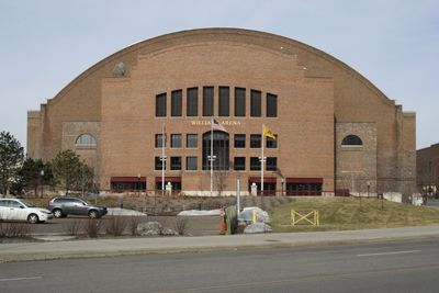
Here's a photo of the arena from when I was
there in 2011.
Right
next to the arena is a Buffalo Wild Wings restaurant which looks to
have been a fire house at one time. Some neat architecture in this
building. Here's a photo of the side with the
markings indicating the building's history. |
 |
I
walked across the street to TCF Bank Stadium, home of the football
Golden Gophers and the temporary home for the Minnesota Vikings. The
Vikings will move into their new home in 2016 (more on this later). TCF
Bank Stadium looks large and small at the same time, depending on the view.
Here are some photos of the stadium.

East side of TCF Bank Stadium in
Minneapolis, MN

Looking through the gate gives this view
of the stadium

Here's another view through the gate. Note how much lower the field is below the plaza level
With just a
little time left before
I had to go pick up my wife at her conference, I drove to the north end
of campus where a footbridge crosses a BNSF rail line. Of course
nothing was coming (just my luck), but the scene is still kind of neat
with the Bunge elevator to the west and multiple tracks to the east
which fan out to serve a couple other grain elevators. Looks like BNSF
is in the process of removing some trackage. Note that the bridge in
the foreground in the first photo is capable of supporting nine tracks!


I then retreated back to the car to resume my listening of the NCAA
tournament on the radio and to pick up my wife.
Friday 3/19/2015
For Friday I had about eight hours to myself. Wanting to see some
mainline rail action I decided to follow the BNSF Staples Subdivision
north to St. Cloud, then follow a partially active line southwest, then
finally
follow a CP line back east to Minneapolis. Under normal driving
conditions the
trip could be done in less than four hours and I generally double the
time to get to how long it would take for me to travel the route.
On
the way up to picked up the BNSF line just north of town I
crossed
an industrial track which had this crossing signal protection. I
believe this is a modified wig-wag signal (minus the wig-wag).
|
 |
A
little farther north from here is a large BNSF yard where several lines
come together. After researching the maps for today's trip and then
seeing this yard and others around town, I completely underestimated
the amount of rail activity still in place in Minneapolis and am amazed
at how much more there was years ago. I always pictured Minneapolis
rail-wise as some division point but never thought of it as a rail hub
of sorts. The Minnesota Rail Map which can be found at http://www.dot.state.mn.us/ofrw/maps/MNRailMap.pdf
illustrates this very nicely. Minnesota rail-wise is kind of
the
inverse of Ohio in that Minnesota has more lines in the south and less
in the north, while Ohio is the opposite.
A brief drive by the
yard yielded nothing but photos of it in my mind. I do recall seeing a
lot of power which looked to be in storage including several BNSF
SD75Ms still in Santa Fe Warbonnet paint. Several oil or ethanol tank
trains were in the yard awaiting crews for the next leg of their
journey. The hump was busy humping cars as well.
I then began to
follow the BNSF Staples Subdivision (ex-Great Northern) north out of
town. Someone took the
trouble to make a nice Wikipedia page on the line at http://en.wikipedia.org/wiki/Staples_Subdivision
. Relying on the GPS, it showed several road crossings along the way
which I occasionally crossed. One thing I noticed was that almost every
crossing was a "silent crossing" with no train horn allowed. All
crossings either had four quadrant gates or two gates with a median to
prevent people driving around the gates. I found this surprising
considering the volume of traffic on this line and the maximum speed
allowed.
I
thought I would get out of traffic congestion sooner than I did and in
the process of getting out of town missed at least two inbound trains
and one outbound train that had CSX power on the head end (yet again -
I go out of CSX territory and sure enough the first train I
see has CSX power). North of Ankola, state route 10 parallels the line
very closely
in most spots making this an easy line to check out. At Ramsey, I got
off of Rt. 10 to check out the Northstar commuter station and was lucky
enough to see this local heading back toward Minneapolis. Nice to see
4-axle power on a local!

Here's a view of the Ramsey transit
center serving the Northstar commuter train

BNSF local at Ramsey, MN heads toward
Minneapolis
A little farther north I stopped at the Elk River Northstar commuter
station to check out the platform.

Elk River, MN Northstar rail platform
looking toward Minneapolis

Elk River, MN Northstar rail platform
looking toward St. Cloud

This sign warns pedestrians of high
speed trains. Should this instead read "higher speed trains?"
I
got back on Rt. 10 and heard the defect detector go off for a location
about five miles east of where I was. So I pulled off the road into a
conveniently placed parking lot and saw this train. Once again, I'm in
Minnesota, I expect to see BNSF power, yet instead I see NS power.

Here comes a NS, er, BNSF train around
the curve at Elk River, MN

The right of way here looks like it may
have supported a center siding at one time

Apparently this train warrants two
buffer cars on the head end
An
interesting things about this line is that it has three stretches of
single track which are governed by track warrant control (TWC) verbal
instructions versus CTC signals. For such a busy stretch of track I
figured TWC would be a thing of the past. There are signals on these
pieces of trackage but they would be ABS and only give indications for
the track ahead. Maybe this is something BNSF will upgrade at some
point. I'm sure Warren Buffett could afford to throw a few dollars at
it.
I
was approaching one of the stretches of single track and
heard the dispatcher giving track warrants and it sounded as if a meet
was taking place. So I found an out-of-the-way road crossing to see
this train. This photo was taken just before a set of crossovers which
I think was called 421 (don't hold me to that). The train on the left
is the train seen earlier in Elk River and the one ahead of it has the
CSX power.

Interesting track arrangement at this
spot. Note the nice grade uphill here as well.

BNSF train heads toward Minneapolis.
Note there are three people in the cab.
Continuing
northwest I made a brief stop at Big Lake which is where the Northstar
commuter line begins/ends. I was hoping to see some equipment tied up
on the station track pocket but was not so lucky. The schedules for the
Northstar commuter trains are stacked for rush hour movements so
everything was in Minneapolis at this time. A little further north
in Becker is a spur for a large XCel Energy plant. It appears this
plant has a balloon track for quick unloading of coal. As an aside, the
few small grain elevators I passed do not have rail service. The
days of small elevators getting service appear to be over along this
line.
Eventually I arrived in St. Cloud which is the first stop
outside of Minneapolis for Amtrak. Unfortunately I was either very
early or very late to see the next Amtrak train depending on how you
looked at the schedule. Here are some photos
of the depot area. It's interesting to note that there is a bay window
on the trackside of the depot and curiously on the opposite side as
well. Unfortunately the Wikipedia article at http://en.wikipedia.org/wiki/St._Cloud_%28Amtrak_station%29
doesn't reference this oddity.

Amtrak (ex-Great Northern) depot at St.
Cloud, MN

Another view of the depot in St. Cloud, MN. It will be several hours before Amtrak arrives.

Looking southeast toward the former
diamond location between two lines in St. Cloud, MN
At this point is where I took a left
turn and began to follow the Northern Lines
Railway southwest out of St. Cloud.
This branch line snakes its way through St. Cloud then fans out into a
yard where I found this train switching cars.

Here's the Northern Line Railway
switching cars in the yard at St. Cloud, MN

A closer look at the power which
provided some great sound effects throttling up

Looks like NLR 1411 has been through a
rebuild or two over its lifetime
A nice depot is on the property of the yard. I
had plans to drive on the lot to get a quick grab shot but a group of
local residents was outside talking (apparently oblivious to them that
it was raining) so I decided not to arouse suspicion and kept driving.
A little further south I found this old railroad building which is now
being used by the St.
Cloud Amateur Radio Club WØSV. The club's tower is just out
of view to the left.

The
line splits just west of the yard with a 2-3 mile stub heading straight
west. Here's a look at the line with a switcher drilling cars at the
end of the line in the distance. I found the date of 1939 on the rail
to be interesting as I don't recall seeing much rail rolled around the
time of World War II.

Close up of the rail showing 112 lb
weight which is typical of a branch line

The 1939 date was one I haven't seen
very often on rails

In the distance a NLR train switches a
customer at the end of the line
Instead of catching up with the NLR train switching I decided to follow
the other line to the southwest. The
line looked to be in decent shape
probably good for 20 mph. There are only a couple customers on
the line
but they all seem to have potential to generate a lot of cars, mostly
in aggregates and grain. The last customer is a quarry just east of
Rockville. Here the line transitions from clear to overgrown
with
grass but is still in place. The
rail map shows it abandoned but I think railbanked is a better term. A
few miles east in Cold Spring the line ends and becomes a multi-use
path for pedestrians and bikes
in the summer and snowmobilers in the winter. This ends in Roscoe.
Needing
to make
up some time I diverged from the abandoned RofW and made it to
Paynesville where
I picked up the CP (ex-SOO) line which would take me back to
Minneapolis. The
line I was following earlier used to cross about a mile west of here.
Here's
the scene at this location.

CP line at Paynesville, MN looking east.
Locomotives are occupied but stopped.

Looking west at Paynesville, MN. The
signals have LED lights and look to be new.
Contrary to the two lines I was just
following, this one does not closely parallel any particular road so a
lot of zig-zag driving was required. I stopped at this location a
little east of Paynesville. The line's sweeping curve would make for a
great
photo if a train was present.

Without the radio frequency for
this line I was basically flying blind so I had to rely on signal
indications and frequent road crossing checks to see if anything was
coming. I was fortunate enough to see the following westbound pulling
hard up hill just west of Eden Valley. Interesting that this dirt road
had flasher/crossing gate protection.

CP westbound pulling hard up the grade
west of Eden Valley, MN.

CP westbound west of Eden Valley, MN
with UP unit trailing.
Continuing
east the line becomes more hilly and
boasted some decent grades for territory I figured had gentle grades at
best. Another observation was that the signals further east were older
than those when I first picked up the line in Paynesville. Apparently
the signal
forces haven't gotten this far east in updating the signals. A little
further east in Kimball I passed by a small rail yard full of hopper
cars but I did not see any signs of what the facility was for. The
satellite maps don't offer much of a clue, either. My guess is that
this is a car repair/cleaning facility but that's probably far off.
Here's a
photo of the grain elevators in Kimball. Unlike the BNSF line, the CP
line has a few smaller elevators with rail spurs.

And this bridge was just east of Kimball.

The signals
were indicating that something was coming west but again without the
correct frequency I had no clue where anything was. Just east of Maple
Lake I saw the train coming and was able to SAFELY stop the car and take a
photo through the windshield. Not a bad grab shot if I do say so myself!

Eventually
I arrived in Buffalo (until now I didn't know there was a Buffalo, Minnesota) which has a nice depot that is
likely used by
MofW forces. The roll up door by the bay window definitely looks like a
newer modification. Searchlight signals also still exist here.

Here's a nice looking depot at Buffalo,
MN. This appears to be used by maintenance crews.

CP line looking west at Buffalo, MN.
Note the searchlight signal.

CP line looking east at Buffalo, MN. The
line has a nice grade uphill this direction.
Just
west of this town is Varner Lake. Despite the mild mid 50's temps,
several
people were ice fishing. Here's one brave soul on the ice.

From
this point on I more or less just followed the route via Highway 55
which parallels this part of the line fairly closely. Along this line
in Hamel is a Loram rail maintenance of way building. I'm not sure if
this is where they build the equipment or just a maintenance facility.
The line then is mostly in residential area and grade separated at most
points. At this point I was just about out of time anyway so this was a
good stopping point for the trip.
Saturday March 19, 2011
On
Saturday I had less time than Friday but more than Thursday to check
things out. As I did last time I was here, I decided to check out the
downtown Minneapolis area on my last day. But before I would do that I decided to ride
the Metro Green Line to St. Paul to check out the newly reopened Union
Depot. I went to the Stadium stop just outside of TCF Bank Stadium
and purchased an "Event Pass" which gives you six hours of unlimited
trips on the LRT and bus for $4. Here's a photo of the station on
a crisp Saturday morning.
|
 |
The Green Line east of the station was
mostly built in the middle of University Avenue. The speed limit for
the road is 35 but the LRT can go 40 which makes it faster than the bus
which stops more often and is at the mercy of the LRT at most
intersections. There are several stops along the route but the trip
from the Stadium station to St. Paul was only about 20 minutes. The
line ends in front of the station. Here are some photos of the outside.

Green Line station at St. Paul, MN with
convenient access to Union Depot.

Here's the front of the St. Paul Union
Depot which was reopened in May 2014.
Inside
the main room the ticket booth has been repurposed as a restaurant or
some sort of assembly gathering place. Nice to see it still in place
but too bad it isn't being used for its original purpose.

Inside the main concourse at St. Paul,
MN Union Depot

Another view inside the main concourse.
The natural
light nicely illuminates the room.
At
this point I simply wandered through the station to the track area.
When I got to the waiting area for the trains I noticed that a yoga
class was in session. There were two co-eds on the LRT with yoga mats
and now I know where they were headed to! Here are some photos of the
station.

Entrance to the corridor which leads to
the station platforms.

Lots of seating available for when
passengers have to wait for the next train or bus.

This part of the station extends over
the rail passenger platforms. Yoga class in the distance!

This looks west where the tracks used to
go under the station. The bus pad is to the left.

This gives a view of where passengers
board Amtrak.

Each set of green double doors
represents what used to be stairs leading to a track below.

Inside one corridor are photos and other
rail items from years past.

Gate C is where Amtrak loads/unload. The
yoga class is in session to the right of the gate.

Just in case you needed to reorient
yourself, we're in the Central Time Zone.

Another view of this area. Notice the
people on the left playing ping pong to kill the time.

Now we see why there are so many people
in the station - Amtrak is running late!

This picture gives a view of the station
from across the street near the river.
I then got back on the Green Line LRT for the return
trip. Back in Minneapolis I repositioned closer to downtown to check
out the Mississippi River area. Despite the mid 30s temperatures and
brisk wind there were a lot of people out walking/running/biking. I
decided to make a big loop around the area south of the Upper St. Anthony
Falls Lock and Dam location. According to http://www.walkjogrun.net/
my route was just over two miles long. Here are some sights along the
way.

View of Minneapolis from the Great
Northern rail bridge which now is a recreational path.

View of the Mississippi River looking
north in downtown Minneapolis, MN

View of the Mississippi River looking
south in downtown Minneapolis, MN

The Great Northern rail bridge has been
given a worthy designation due to its construction.

At the west end of the bridge, the locks
await their next water craft

This sweeping view of the bridge nicely
illustrates its impressive construction

Many of these old factories have been
converted to loft apartments.

This is the replacement I-35W bridge for
the one which collapsed several years ago.

This former rail bridge is south of
downtown by a half mile or so and is also now for pedestrians.

View looking north from this rail
bridge. Note the second set of locks and dam.

View looking south from this rail
bridge. The U. of Minnesota logo is on the bridge to the south.

This is just beyond the east end of the
rail bridge and shows where the track used to go.

Most of these rail cars are loaded,
probably considered "constructively placed" by the RR.

The tracks end a little north of the
truss rail bridge but show how much rail activity there once was.

One track extends to the power plant on
the left. The date on the rail shows 1952, 132 lb. rail.
By this time my
nose, ears and other extremities were getting quite chilly so it was
time to warm up with some lunch and check in with the NCAA basketball
tournament games. After lunch I headed across the river to check out a
few
buildings I found to be interesting when I was driving around earlier.
So again I fed the meter and started walking. Fortunately the sun had
come out by this time. First, this old Armory building grabbed
my
attention.

Here's the county courthouse which looks quite sturdy.

And the old Milwaukee Road depot and train shed is now a hotel.

A
little further down is the Mill City Museum celebrating the massive
milling operations that once existed in this part of downtown.

Finally
I reach the construction site for the Minnesota Vikings' new football
stadium. This is on the site of the old Metrodome which, when we were
here in 2011, was deflated and its disposition still in question. The
new stadium is going to be massive, and the cranes being used to
construct the building are just as impressive.

Multiple cranes being used to construct
the new Minnesota Vikings stadium.

East side of the new stadium. The large
truss on the right I believe will eventually support the roof.

This panel piece, towering over the
large crane, illustrates the size of the overall structure.

The Metro Blue Line LRT goes right by
the east side of the stadium. No need to drive!

Here's a better view of the large truss
and how it will connect with the rest of the structure.

The west side of the stadium is not as
far along as the east side. The LRT is just to the left.
This walk around
downtown was 1.5 miles so I'm getting my exercise in! With about an
hour to spare I head over to the Basilica of St. Mary which is tucked
away on the southwest side of downtown. The building just celebrated
its 100th anniversary last year. Here are some photos of the inside.

View from the back of the basilica. Many
people were there to admire as well as to pray.

This view illustrates the size of the
cross in the middle as well as the ornate curved ceiling.

Pipe organ chambers flank the altar area
on each side in the front of the church.

Here's a view of the organ console built
by Wicks. The organist looks to have a lot available.

View from the front looking toward the
back. Note the large wood pipes on the right side.

This is looking up into the dome in the
front of the church under the altar.

Here's a view of the tabernacle area
which is surrounded by statues of saints.

Another view of the front. Note the
communion rail still in place in the front.

View from the front looking back. The
cross makes an impression in this photo.
At this point my time was up so I picked up my wife and we began our
journey home.
Questions,
comments welcome!
Back to Trains
Home index


